 ar
ar bg
bg hr
hr cs
cs da
da nl
nl fi
fi fr
fr de
de el
el hi
hi it
it ko
ko no
no pl
pl pt
pt ro
ro ru
ru es
es sv
sv tl
tl iw
iw id
id lv
lv lt
lt sr
sr sk
sk sl
sl uk
uk vi
vi et
et hu
hu th
th tr
tr fa
fa ms
ms hy
hy ka
ka ur
ur bn
bn mn
mn ta
ta kk
kk uz
uz ku
ku
Sliding Inclinometer
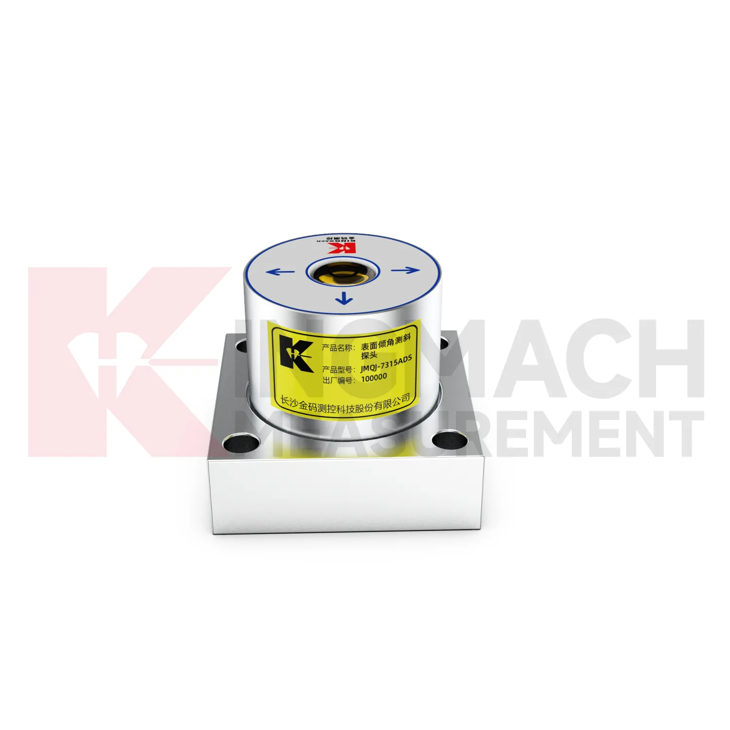
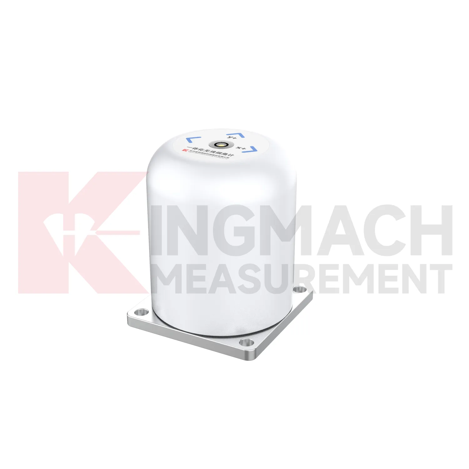
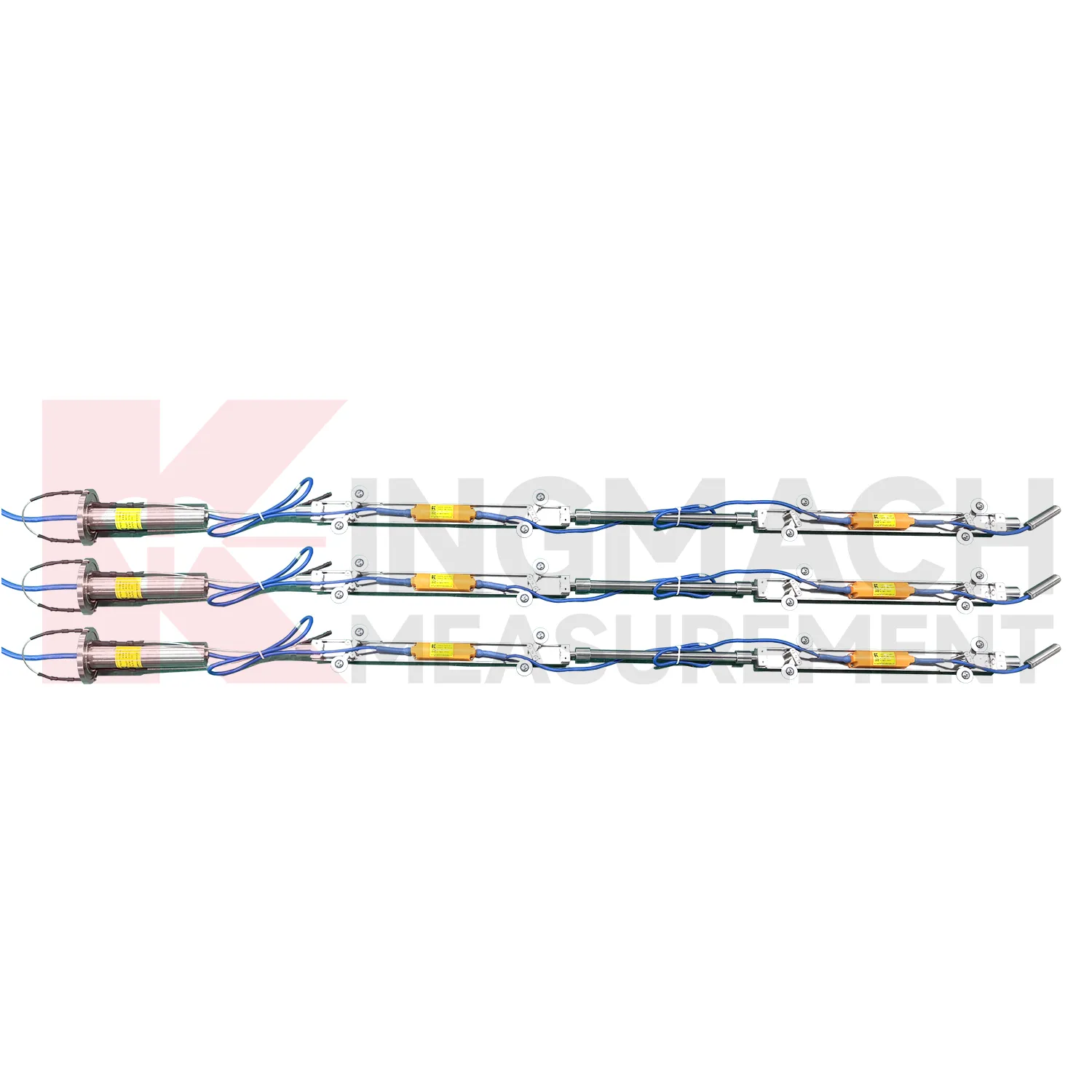
Kingmach Sliding Inclinometer use different communication paths for different field needs. JMQJ-7315ADS uses RS485 digital output and works well in wired automated systems. JMQJ-7315RTU uses wireless 4G digital output and is better suited to sites where cables are difficult to run or where remote unattended measurement is expected. JMZX-7100L uses Bluetooth for mobile field reading and can store large amounts of inclinometer data for later analysis. JMQJ-7915ATS and JMZX-4QH support downhole multi-point data collection through grouped communication and acquisition modules. Communication planning should define cable route, antenna position, cabinet protection, baud rate, channel address, sampling interval, power mode, and fallback manual check method. The communication method is part of measurement quality because lost data, wrong channel names, or unstable power can confuse the tilt trend.
Application of Sliding Inclinometer
Integrated monitoring platforms use Sliding Inclinometer as the angular deformation layer in a broader site record. A project may combine fixed tilt sensors, in-place inclinometer strings, displacement meters, settlement gauges, load cells, strain gauges, environmental sensors, data loggers, cables, and visualization software. Kingmach offers both tilt instruments and related acquisition products, so the monitoring plan can connect measuring points to platform channels from the beginning. The main task is to define which tilt point answers which site risk: wall rotation, pier movement, deep slope deformation, building lean, or tunnel lining response. Alarm levels should be based on that risk and reviewed with nearby instruments. When the platform displays tilt beside related data, engineers can judge linked behavior more quickly.
The future of Sliding Inclinometer
Wireless monitoring will play a larger role in future Sliding Inclinometer projects. JMQJ-7315RTU already combines MEMS tilt sensing with 4G digital output and battery power, which helps when cable routes are long, exposed, or disruptive. Future projects will likely use wireless tilt points on bridges, buildings, slopes, towers, and temporary construction structures where fast deployment matters. Wireless work still needs disciplined planning: antenna location, sampling interval, battery status, data upload timing, and fallback field checks must be defined. The best wireless tilt record will not simply send more data; it will send the right data with enough context for engineers to understand what changed, when it changed, and whether the site needs inspection.
Care & Maintenance of Sliding Inclinometer
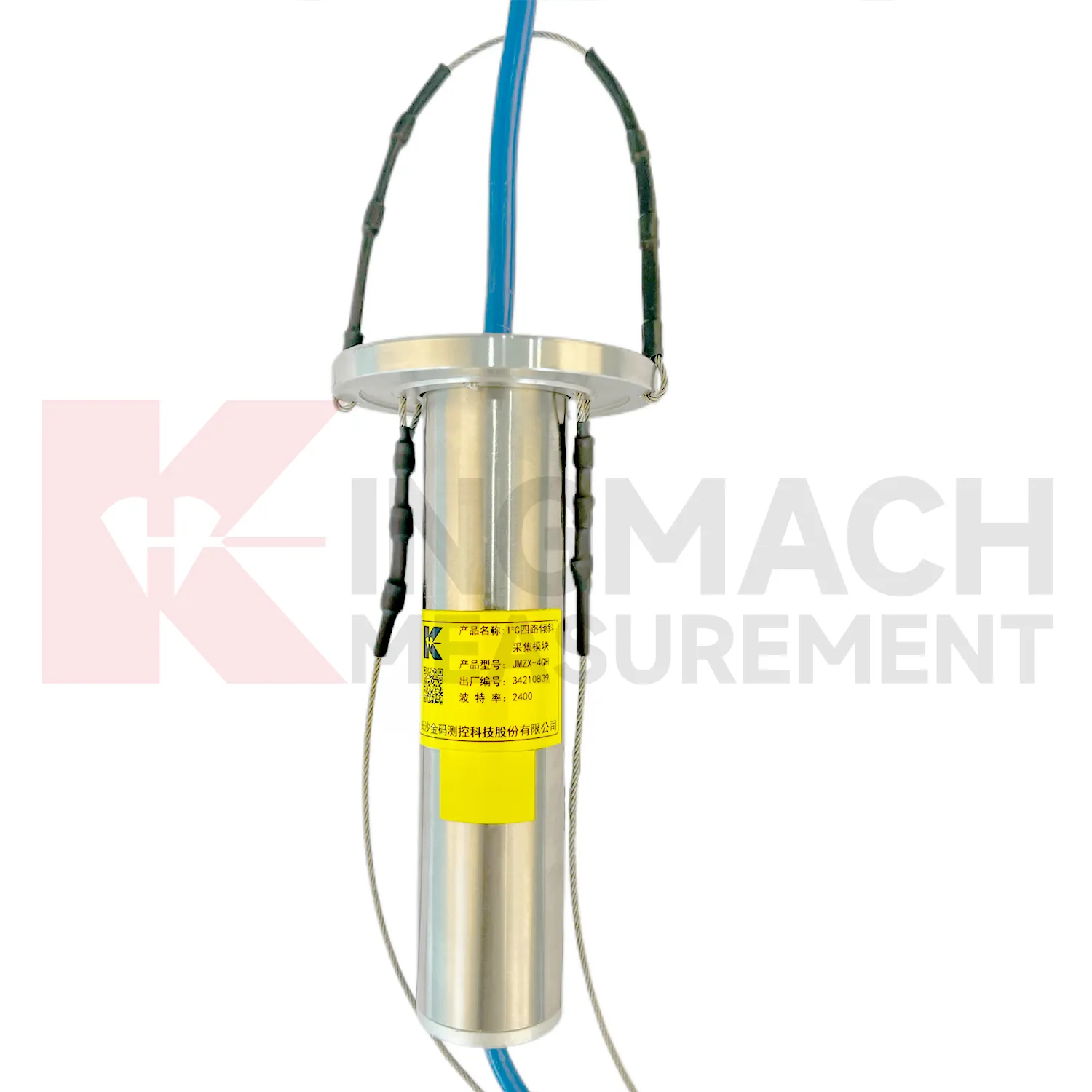
Borehole systems for Sliding Inclinometer need careful mechanical and data maintenance. JMQJ-7915ATS uses a multi-point tandem inclinometer string with universal joints, connecting rods, suspension, cables, and an orifice acquisition module. During installation, record measurement spacing, borehole ID, casing condition, orientation, group assignment, and factory configuration. During inspection, protect the orifice, check cable strain, review module status, and compare depth points for abnormal jumps. If one depth changes sharply while neighboring depths remain steady, inspect both the ground condition and the instrument chain. Borehole data is most useful when every depth point remains tied to a clear physical position and a stable orientation reference.
Kingmach Sliding Inclinometer
Kingmach Sliding Inclinometer help turn difficult-to-observe deformation into repeatable engineering evidence. Hidden parts of structures are often the hardest to judge: deep soil, buried retaining systems, bridge substructures, railway bases, foundation pit walls, and underground construction zones. Tilt measurement gives engineers a way to see angular change before visible damage becomes obvious. The product category is used in bridges, tunnels, slopes, buildings, foundation pits, geological hazard areas, railways, dams, embankments, port engineering, and other structural scenarios. The monitoring record should connect each sensor to a drawing location, axis label, baseline date, power source, communication path, and related construction activity. Without that context, even a precise angle may be hard to interpret. With it, tilt data can support timely inspection and measured engineering decisions.
FAQ
Q: How accurate is the JMQJ-7315ADS tiltmeter?
A: The product page lists 0.001 degree resolution and 0.01 degree accuracy for the +/-15 degree dual-axis model.Q: What protection grade does JMQJ-7315ADS have?
A: It is listed with IP68 waterproof protection and an operating environment from -30 degrees Celsius to +80 degrees Celsius.Q: What range does JMQJ-7315RTU provide?
A: The integrated wireless model lists +/-30 degree and +/-15 degree dual-axis range options, with 0.001 resolution.Q: How many sensors can JMZX-4QH support?
A: The module lists four channels and support for up to 100 sensors in a multi-point inclinometer system.Q: What is the guide wheel spacing for JMZX-7100L?
A: The sliding inclinometer page lists a 500 mm guide wheel spacing reference and a +/-90 degree sensor range.
Reviews
Michael Anderson
The strain gauges and load cells are extremely accurate and stable. They performed very well in our bridge monitoring project. Highly recommended!
Robert Taylor
The weir flow meter is well-built and delivers accurate measurements. Great value for water management applications.
Latest Inquiries
To protect the privacy of our buyers, only public service email domains like Gmail, Yahoo, and MSN will be displayed. Additionally, only a limited portion of the inquiry content will be shown.
Emma***@gmail.comCanada
Dear Sir/Madam, we are interested in displacement transducers and settlement sensors for a geotechni...
Isabella***@gmail.comGermany
Hello, we are evaluating weir flow meters for a water management project. Please share accuracy deta...